
Flood of reports and studies keep coming to detail the causes and consequences of September deluge. Saima Bhat highlights the flood report prepared by using the satellite images
 For the first time in the history of Jammu and Kashmir, satellite images were used to report the tendency and effects of September floods. These images were used in the compilation of a report, titled ‘A satellite-based rapid assessment on floods in Jammu & Kashmir–September, 2014’ conducted jointly by the Department of Environment & Remote Sensing (DERS) and Indian Space Research Organization (ISRO).
The said report has revealed that the recent flood was the worst flood in past 60 years, which inundated 557 sq kms of Kashmir Valley and affected 22 lakh people. (table 1).
The researchers have blamed unprecedented and intense rains from September 01 to 06, which lasted for about 30 hours. It is said that major parts of the state recorded an average of more than some aspects of catastrophic rain fall while as some parts of the state experienced more than 650mm of rainfall in 3 days. Earlier Kashmir valley has experienced such intensity of rainfalls in 1903,1911,1917,1928 and 1992.
Although rain in Jammu region during September has been a normal phenomenon but this year its intensity was very high. In Jammu region such huge rainfall has been earlier recorded in 1903, 1908, 1926, 1942 and 1988. Even moderate rainfall was also recorded in Ladakh region.
Report suggests proper precautions like alternate flood spill channel for Jehlum, widening of rivers and lakes, de-siltation besides other measures are the need of hour to prevent flood devastations in future.
As per the report, the pattern of rainfall starting from September 2 was confluence of three rain-bearing systems over Punjab, which drew copious amounts of moisture into north India in a five-day spell and that wreaked havoc in J&K, the worst sufferer.
“The state had a deficit of 32% on September 3 which in a span of five days was transformed to 18% excess rains — a change of 50 percentage points. While as analysis of pre and post flood satellite images have revealed that snowmelt had a very little role to play as the post flood image showed more snow than pre flood image. Snouts of Kolhai Glacier were found almost intact. However, fresh snowfall might have occurred during flood days that were washed away by incessant rains resulting in cold flood water,” reads the report.
While analyzing the cumulative rainfall from September 01 to September 06 (2014), it was observed in the report that Lidder Catchment received maximum amount of rainfall, 277mm with adjoining catchments in South Kashmir- Arpal, Bringi, Kuthar, Sandran, Vishaw, also receiving rainfall above 200mm.
The results reveal South Kashmir region received maximum amount of rainfall during August 28 to September 10 this year which developed a deep depression. From September 03 to 06, Shopian district received 2953%, Kulgam 1850%, Anantnag 1687% and Pulwama 2380% excess rainfall over normal in the week ending September 09, 2014 amounting to cloudbursts. All districts except Poonch received high rainfall.
Due to the heavy downpour of around 650mm on September 04, the glaciers and hard rocks produced lot of run-off, the soil of the region was already saturated and then the incessant high rainfall for more four days generated unprecedented floods, raising the flood level of Jehlum at Sangam to 34.70 ft (danger level 21).
It led to the abrupt increase in the flood level at Ram Munshi Bagh which touched around 29.50ft (danger level 18). This was boosted by the heavy rains in Sindh basin (105mm) resulting in heavy discharge in Sindh Nallah which joins the Jehlum at Shadipora causing an upward rush and limiting the free flow of Jehlum water into the Wullar Lake which had the necessary detention capacity at that point of time.
|The flood inflow was more than the combined carrying capacity of Jehlum and flood channel despite the natural breaches of huge size at Kandizal, Chursu, Lelhar, Marwal, Khadermoh, etc,” reads the report.
As per the earlier records, the discharge of Jehlum at Sangam was about 80,000 cusecs during 1928 floods and 100,000 during 1959 floods. Meanwhile in 2014, the discharge was reported to be highest ever recorded at 1, 35, 000 cusecs on September 06. This figure doesn’t include the breaches (reportedly-84) of river Jehlum (I&FC).
Reports also suggest the carrying capacity of Jehlum, in Srinagar city is about 35,000 cusecs and another 15,000 in the supplementary channel.
Flood Inundation
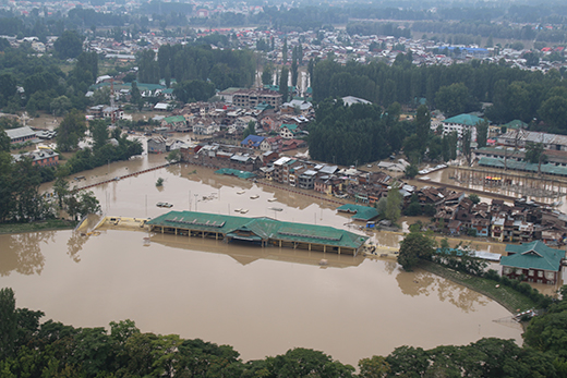
As per the satellite images from September 08 to 25, the total area inundated by floods was recorded to be about 557 km2, which constitutes about 3.5% of the Kashmir Valley’s geographical area, was inundated due to flooding.
According to the satellite data, Bandipora was the worst affected with its 148 sq kms area coming under water. In Srinagar district, worst affected, 100 sq km area was inundated. Here the problem was acute as most of the inundated area comprised of high density residential areas. (table 4)
Meanwhile in Jammu region, the satellite images show the rainfall events across region resulted in triggering flash floods and a number of landslides especially in south of the Pir-Panjal range, in Rajouri, Bhuvan and Mahore areas.
The satellite image of September 07 have even showed marked increase in the width of Jehlum and Chenab Rivers, whereas in the same image Kashmir valley is seen covered by clouds.
As per the report, DERS and ISRO blame climate change and then the changed ecology as the main reasons behind September 2014 flood. And says such kind of situation may arise in future as well. (table 3)
As per the Indian National Network for Climate Change Assessment (INCCA 2010), the frequency of rainy days is more in East and North-East India and less over western India. Projections for the 2030s indicate that the frequency of rainy days is likely to decrease in most parts of the country.
However, the intensity of rainy days will increase in a more warming scenario. The number of rainy days in the Himalayan region may increase by 5–10 days on an average in the 2030s. They will increase by more than 15 days in the eastern part of the Jammu and Kashmir. The intensity of rainfall is likely to increase by 1– 2mm/day, with some areas of J&K showing an increase up to 50%.
The researchers also blame ‘encroachments’ on the river basins, closed flood spill channels and wetlands for the 2014 floods:
“Various flood spill channels were dug during the reign of various kings, maharajas, administrators in the past. The Nalamar road channel was dug during the reign of the great Kashmiri king, Zain-ul-Abidin while as the Tsunt Khul Nallah was dug by Mehan Singh in 1835 AD with the sole purpose to save Srinagar city from floods. Nature has bestowed a vast network of wetlands and waterways locally called “Dembs” to the Srinagar city which acted as sponges during the floods and shared the Jhelum waters, but during the last few decades due to rapid urbanization, these wetlands and water ways were converted in to built-up. Also, not much attention was given towards de-silting of the existing flood spill channels.”
Reports suggest that Wetlands in Kashmir valley have lost their water absorption capacity due to excessive siltation and encroachments, thus decreasing the chances to provide assistance during floods. Wetlands including Hokersar, Haigam and Shalabugh, considered as natural sponges in times of floods – have been converted into “agriculture and built-up” over the past two decades which worsens the flood susceptibility.
As per another research done by Humayan Rashid and Gowhar Naseem, of Jammu and Kashmir Remote Sensing Centre reveals the loss of nearly 50% of the wetlands over the period of 100 years.
| Table 5:extent of Lakes and wetrlands in Kashmir valley(1911- 2011) | ||||
| S no | Year | Category | Total (km2) | |
| 12 | 19112011 | Marshy | Water body | 356.85158.54 |
| 271.71117.43 | 85.1541.11 | |||
| Loss in spatial extent | 154.27 | 44.04 | 198.31 | |
The results also revealed that area under agriculture has drastically reduced by 11.65% followed by the plantation 8.35% and wetlands and water bodies by about 3.77 and 1.49% respectively.The report suggests that the Kashmir region has recorded a huge loss of forest since 1992. And the most important, the built-up area, computed from temporal data for Srinagar City, indicated that area under built-up in 1972, 1982, 1992 and 2004 was 18.10, 27.23, 41.80 and 84.50 km2 respectively. Thus over the years the amount of built-up land has grown by about 29.20%, nearly three times the rate of population growth.Loss of water bodies are also believed to be reason for the increased local micro-climate with the mean temperature in summers rising to 39.5 degree Celsius in 2006 as compared to 35.5 degree Celsius in 1973, the study reads.
Table 1: showing extent of inundation from 08-25 September, 2014
S.NO. DATE AREA (km2)
1 8TH September 2014 370.6
2 9TH September 2014 361.2
3 10TH September 2014 358.6
4 12TH September 2014 338.6
5 15TH September 2014 312.3
6 17TH September 2014 291.7
7 19TH September 2014 282.9
8 21ST September 2014 271.3
9 25TH September 2014 251.9
Table 4: CITY LEVEL DETAILED LAND USE/LAND COVER INUNDATED BY FLOODS:
S.NO. LAND USE TYPE AREA (km2)
1 AGRICUITURE 34.10
2 COMMERCIAL 32.21
3 EDUCATION 1.90
4 GRAVEYARD 0.40
5 HILL 1.00
6 MEDICAL 0.53
7 OPEN 12.39
8 ORCHID 0.10
9 OTHER 0.25
10 PARK 0.78
11 PARKING 0.06
12 PLAY GROUND 0.61
13 POLICE STATION 0.24
14 REFUSED 0.28
15 RELIGIOUS 0.65
16 RESIDENTIAL 28.11
17 RESIDENTIAL+COMMERCIAL 0.58
18 RESTRICTED AREA 4.05
19 SLUM 0.01
20 TRANSPORT 0.08
21 VACANT 0.44
TOTAL 118.75
Table 3: Summarized Land use over the years and percent change in Land use
S.No. Description Years Percent Change
1976 1981 1991 2001 (1976-2001)
- Agriculture 83.55 80.59 78.12 57.06 -11.65
- Barren Land 1.39 1.39 1.39 1.39 0.00
- Built-up 18.10 27.36 41.80 84.50 29.20
- Forest 5.70 5.56 5.52 2.94 -1.21
- Graveyard 0.58 0.58 0.58 0.98 0.18
- Horticulture 22.82 20.59 18.60 15.98 -3.01
- Landfill 0.23 0.93 1.00 1.03 0.35
- Plantation 41.54 40.80 35.73 22.54 -8.35
- Quarry 0.21 0.21 0.21 1.20 0.44
- Recreational 1.89 1.99 2.00 2.05 0.07
- Road 0.32 0.52 0.56 0.83 0.22
- Wasteland Scrub 8.50 7.84 5.68 6.29 -0.97
- Waterbody 14.92 13.92 12.49 11.54 -1.49
- Wetlands/Marshy27.66 25.14 23.74 19.09 -3.77
Total 227.41 227.41 227.4 227.41
o


